Bringing together 10 map services into one user-friendly “Tokyo Map”
“Where can I find safe and secure free Wi-Fi?”
“Where can I find a water fountain?”
“Where are wheelchair-accessible restrooms?”
The Tokyo Metropolitan Government has provided numerous map services to answer these kinds of questions from locals and visitors. However, because the maps are divided by category, people often find it hard to know where to look for which map. Here in the GovTechTokyo Data Strategy Division of the Digital Strategic Department, we have addressed this by developing and operating “Tokyo Map”. This map brings together 10 map services for Tokyo all in one place, it gathers map information from various departments of the Tokyo Metropolitan Government and allows users to view it all overlaid.
In this blog, we will discuss how we embarked on this journey to develop this useful map and take you through from inception to launch.
It started with a partnership agreement
In September 2025, the Tokyo Metropolitan Government signed an agreement with Google LLC regarding cooperation and collaboration to promote digital transformation throughout Tokyo. This agreement aims to promote collaboration in a wide range of fields, including the creation of advanced services and the utilisation of AI and data generation, in order to realize “Smart Tokyo,” as outlined in the “Tokyo 2050 Strategy.”
During the consideration process, they focused on providing information starting from “maps.” Various types of information held by the Tokyo Metropolitan Government are scattered across different web pages, making it difficult for people to find the information they need. Therefore, they considered the possibility of using map services as a means of delivering information about the metropolitan government services in an easy-to-understand way, using location information as a starting point.
Google LLC is a world leader in the field of geospatial data utilization. They thought that by combining the intuitive usability of Google Maps, which many people use daily, with the highly reliable administrative information held by the Tokyo Metropolitan Government, it would be possible to provide information in a more user-friendly way. This idea became the starting point for “Tokyo Map.”
The Tokyo Metropolitan Government and GovTechTokyo considered what kind of map service would be easy for Tokyo residents to use, and decided on a “small start” policy, beginning small and continuously improving. Based on the premise of providing the service on the Tokyo Metropolitan Government’s comprehensive website, GovTechTokyo proceeded with in-house development, refining the service through repeated prototype development and usability testing.
Taking the “small start” approach
Approximately six months after discussions began between the Tokyo Metropolitan Government and GovTechTokyo, in March 2026, “Tokyo Map (beta version),” which incorporates the following three types of map information, was released (see below). The three maps were:
- Tokyo Water Drinking Station : A map of drinking fountains located in public places. You can choose to display either spout-type or bottle-dispenser-type fountains.
- TOKYO FREE Wi-Fi : A map of Wi-Fi hotspots compatible with the international standard “OpenRoaming”.
- Wheelchair-accessible toilet information : A map of wheelchair-accessible toilets. You can filter by facilities such as ostomate facilities and universal seats.
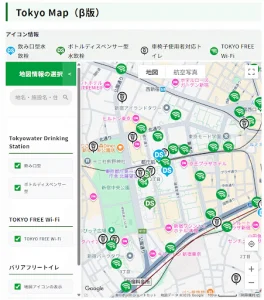
At first glance, these three features may seem unrelated, but they share a common thread: they provide information you need right now while you’re out and about. For example, on a scorching hot day, being able to check water refill locations, Wi-Fi hotspots, and usable restrooms on a single map greatly increases your sense of security when you’re out. The ability to overlay information across different fields is the greatest appeal of “Tokyo Map.”
Another important aspect we prioritised as an official government map is clearly indicating the source of the data. “Tokyo Map” clearly displays the source and links for all the data it includes. This is a key feature we wanted to include, as we want users to clearly see that it’s official information from the Tokyo Metropolitan Government.
Consolidating 10 types of map information through collaboration
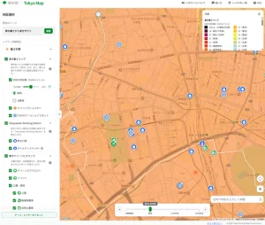
In August 2026, based on the beta version, the official version was released, consolidating 10 types of map information. The official version comprehensively aggregates map information held by various departments of the Tokyo Metropolitan Government. It provides a function that allows users to overlay and display themes related to daily life, such as disaster prevention, heat countermeasures, and accessibility. In addition, we re-analysed the user flow, understanding how users search for and utilise information. Based on the results, we have improved the screen design and expanded and optimised the functions to make the service more intuitive and easy to use.
For example, the image below is the heat countermeasures theme, allowing users to check the heat index and rest/water stations and take precautions to avoid overexertion. This includes the Tokyo Heat Map, Tokyo Water Drinking Stations, and Tokyo Green Biz Map.
The development of “Tokyo Map” is supported by a collaborative system between the Tokyo Metropolitan Government and GovTechTokyo. Based on weekly regular meetings, and sometimes using online tools, agreements are quickly reached with the Tokyo Metropolitan Government. Based on that, we then collaborate with development vendors. This accumulation of efforts leads to both speed and quality.
Furthermore, “Tokyo Map” is built on the “Tokyo Cloud Infrastructure,” which is the metropolitan government’s common cloud platform. Rather than preparing individual environments, we utilise a platform that adheres to the security and operational rules established by the metropolitan government, thereby ensuring the safety and stability required for an administrative service.
We also collaborated with UI/UX (User Interface/User Experience) specialists to define personas and conduct usability tests. Our focus was on ensuring users could easily find the information they needed, and we proceeded with development while verifying ease of use from this perspective.
The release is not the goal, it’s the start
“Tokyo Map” is just getting started. The official version has just been released. There is still a lot of map data available from various departments of the Tokyo Metropolitan Government. We will continue to add this data sequentially and deliver information that supports the lives of Tokyo residents. It’s not just the data we publish that we will expand. We will also continuously review the screen’s readability and ease of operation to match how it is actually used. We will incorporate user feedback and develop it into a service that is easy to use in daily life. We aim to become a service that people say, “When it comes to map information for Tokyo, it’s Tokyo Map.” We will continue to evolve while developing our data to achieve this goal.
Bringing expertise together to deliver resident impact
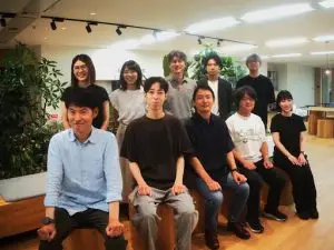
“Tokyo Map” is a project born from the fusion of Tokyo Metropolitan Government’s data and digital expertise. And it’s the combined efforts of each individual, built through daily collaboration, that have brought it to fruition. Our project team includes members with experience in service development in the private sector, as well as Tokyo Metropolitan Government employees. Some are even seconded from the Tokyo Metropolitan Government to GovTechTokyo, where they excel as digital professionals. The blending of knowledge from both the public and private sectors is the strength of this team (see photo of project team below).
Furthermore, the tools we use—the mapping infrastructure, the cloud, and the usability testing—are the same as those used in the private sector. The pace of development is also largely the same. What’s different is where it reaches. What we created directly impacts the lives of approximately 14 million Tokyo residents. There aren’t many workplaces where you can feel the direct societal impact so strongly.
This blog has been translated from the original blog on the GovTechTokyo note website. The original blog was written by GovTechTokyo with contributions from Asahara, Ogura and Hosoya from the Data Strategy Division of the Digital Strategic Department on 4th September 2026.